
Overview
Navigating urban environments on foot should be fundamentally about discovery, convenience, and freedom of movement, yet for many individuals—particularly women, LGBTQ+ individuals, and marginalized communities—personal safety concerns heavily influence routing decisions and travel patterns. Standard mainstream navigation applications (Google Maps, Apple Maps, Waze) optimize exclusively for speed and efficiency, often overlooking user’s legitimate safety requirements by routing pedestrians through poorly lit streets, areas with high crime rates, or locations with documented harassment patterns. Enter Streetwise, launched on Product Hunt in November 2025, a revolutionary safety-first navigation application built with powerful mission to help users find the safest walking routes rather than merely the quickest ones. Born from alarming research findings that approximately 8 out of 10 women in Paris report experiencing street harassment, Streetwise is specifically designed to empower pedestrians—particularly women and vulnerable populations—by providing clear choice between fastest route and safest route alternative, transforming every journey into more confident and secure experience through data-driven route safety assessment and community intelligence.
Key Features
Streetwise delivers comprehensive safety-focused navigation through specialized AI assessment and community collaboration.
Safety Scoring System (1-10 Scale): Every calculated route receives clear, immediately understandable safety score from 1 (lowest safety) to 10 (highest safety). Scoring system combines multiple data inputs including historical incident reports, real-time user submissions, environmental factors (street lighting density, foot traffic patterns, building occupancy), time-of-day variations, and machine learning analysis of harassment and crime patterns. Enables users to assess route safety at glance, making informed routing decisions before embarking on journey.
Crowdsourced Incident Data and Community Intelligence: Platform’s power derives directly from community participation. Users report incidents in real-time through simple “Report a danger” interface documenting harassment, theft, accidents, unsafe conditions, or other threats. Reported incidents automatically geotagged and anonymized protecting reporter identity while updating live safety map benefiting entire community. Moderator verification prevents false reports ensuring data reliability and preventing malicious manipulation. Dynamic updating ensures safety map reflects current conditions rather than historical data.
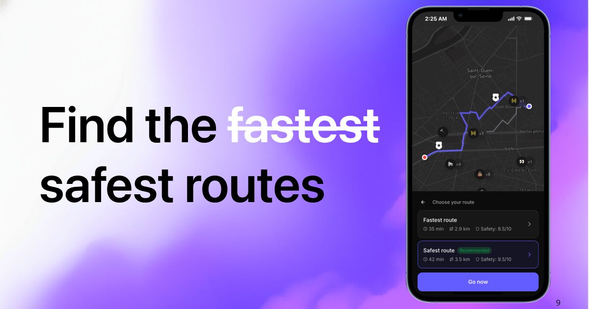
Dual Route Display (Fastest and Safest): Unique platform differentiator compared to traditional navigation apps. Streetwise simultaneously presents both fastest route option and safest route alternative allowing users to consciously choose routing priority based on their current circumstances. Some users prioritize getting home quickly; others prioritize safety despite longer duration. Platform respects user agency enabling conscious choice rather than forcing algorithm’s default.
Fake Call Safety Alarm Feature: When users feel uncomfortable or find themselves in distressing situation, single app tap triggers realistic fake incoming phone call providing plausible reason to leave area quickly or change behavior without confrontation. Customizable caller ID options and pre-recorded conversation scripts enable users to exit situations discreetly. Feature uses device-level APIs mimicking genuine phone behavior with realistic vibration patterns and background noise simulation deterring potential harassers.
Real-Time Environmental Assessment: Beyond incident reports, platform analyzes environmental factors including street lighting conditions, crowd density patterns, nearby businesses and establishments (libraries, police stations, open venues) providing sense of security around specific areas. Time-of-day analysis recognizes that same street presents vastly different safety profiles during daylight versus nighttime.
Automated Route Avoidance: High-risk zones recently flagged by incident reports or consistently low safety scores automatically excluded from generated routes unless explicitly overridden by user. Machine learning algorithms learn from collective community experience continuously refining area risk assessment preventing users from unknowingly routing through danger zones.
Location Sharing and Emergency Features: Users can share real-time location with trusted friends/family members with automatic notifications if journey takes unexpected turns or if user doesn’t arrive within expected timeframe. Integration with emergency contact protocols enabling rapid assistance if needed.
Offline Capability with Sync: Core map and safety data available offline enabling safe navigation even in poor connectivity areas. Real-time incident reports sync automatically upon reconnection maintaining data currency.
Pricing
Streetwise operates on completely free model with no premium tiers or hidden costs.
Completely Free: All platform features available at zero cost including safety scoring, dual route routing, incident reporting, community data access, fake call feature, and location sharing. Development costs covered through municipal partnerships, nonprofit grants dedicated to urban safety initiatives, and social-impact funding enabling genuinely free access for all users without monetization through ads, data sales, or feature restrictions.
No Hidden Costs: Unlike freemium models that gate important features behind paywalls, Streetwise maintains commitment to complete feature access without subscription tiers, premium upgrades, or in-app purchases. Safety shouldn’t be gatekept by ability to pay.
How It Works
Streetwise’s operational workflow emphasizes simplicity and community collaboration through intuitive interface and real-time data sharing.
Route Planning Phase: Users enter destination address exactly like traditional navigation apps. Unlike competitors providing single route, Streetwise immediately generates dual routing options: fastest route (optimized for speed/distance) and safest route (optimized for safety scoring).
Safety Analysis: Platform analyzes multiple data inputs including police crime statistics (where available), verified user incident reports, environmental factors (lighting, buildings, foot traffic), and temporal patterns (time-of-day safety variations) generating comprehensive safety assessment for each route segment.
Route Comparison and Selection: Users review both options side-by-side comparing speed versus safety tradeoffs. Some users prioritize arriving quickly; others prioritize security. Platform enables conscious decision making based on user’s priorities and current circumstances rather than forcing algorithm’s default.
Navigation and Reporting: As users navigate, they encounter real-time incident reporting capability enabling quick submission of observed threats, harassment, accidents, or other safety concerns. Reports immediately feed into community safety map improving recommendations for all users.
Emergency Features: If circumstances change during journey, users can trigger fake call alert appearing as incoming phone call providing plausible exit reason. Alternative routing available if user wants to deviate from planned path.
Community Feedback Loop: All user reports, routing decisions, and incident data continuously feed machine learning models improving safety scoring accuracy and route recommendations over time. Platform becomes more valuable as community participation grows creating network effects benefiting all users.
Typical workflow from address entry through safe arrival completes within minutes enabling rapid journey initiation while maintaining safety prioritization.
Use Cases
Streetwise serves diverse populations and scenarios where pedestrian safety concerns significantly impact mobility and life quality.
Safer Walking Home Late at Night: Primary use case—anyone walking home late at night through unfamiliar neighborhoods uses Streetwise identifying well-lit, higher-traffic routes with strong safety scores. Peace of mind dramatically improves knowing route selection prioritized safety rather than speed.
Women’s Safety and Harassment Prevention: Specific target demographic—women and girls experience disproportionate street harassment and assault risk. Platform directly addresses documented safety concerns with specialized routing and community incident tracking enabling women to navigate confidently.
Tourist Navigation in Unfamiliar Cities: Visitors exploring new cities lack local knowledge about which areas are safe. Streetwise acts as knowledgeable local guide helping tourists navigate confidently avoiding problematic areas without requiring local expertise or advance research.
LGBTQ+ Individuals Navigating Hostile Environments: LGBTQ+ individuals in areas with documented harassment or hate crimes use platform identifying safer routes and avoiding areas with known risks or hostile residents.
Students Walking After Dark: University students, particularly women, use Streetwise for safe campus routing and off-campus navigation. Incident reporting builds institutional knowledge about recurring problem areas enabling administration response.
Shift Workers and Late-Night Commuters: Healthcare workers, hospitality staff, and others with late-night shifts use Streetwise for safe commute routing with real-time adjustments based on current incident reports.
Parental Route Planning: Parents reviewing safe routes for children walking to school or activities use incident data and safety scoring informing route decisions.
Community Advocacy: Incident aggregation data identifies patterns enabling community organizations and government agencies to advocate for street lighting improvements, increased police presence, or urban design changes addressing recurring safety concerns.
Vulnerable Population Care: Caregivers planning safe routes for elderly individuals, people with disabilities, or others with specific vulnerability use platform to identify most secure paths.
Pros and Cons
Understanding both advantages and limitations provides clarity for evaluating Streetwise’s fit for pedestrian safety needs and urban navigation patterns.
Advantages
Highly User-Focused Design: Application built from ground up solving genuine real-world problem with pedestrian safety as central focus rather than afterthought. Every feature directly addresses documented safety concerns and user feedback.
Safety as Primary Metric: Every feature from dual routing to fake call alarm specifically designed enhancing pedestrian safety and confidence. Platform recognizes safety as legitimate navigation priority equal to speed and efficiency.
Completely Free Access: All powerful safety features available without payment, premium subscriptions, or feature gates. Universal access ensures safety tools available regardless of economic status or financial resources eliminating digital equity barriers.
Community-Powered Intelligence: Crowdsourced incident reporting creates dynamic, real-time safety map reflecting current conditions rather than static historical data. Community participation drives continuous improvement and collective knowledge sharing.
Transparency and User Control: Dual routing enables explicit choice between safety and speed empowering users rather than forcing algorithm’s decision. Users maintain agency in routing decisions.
Data Privacy and Anonymization: Incident reports stripped of identifying information protecting reporter identity while contributing to community safety map. Cryptographic hashing and block-level location precision maintain privacy standards.
Disadvantages
Limited Geographic Coverage: As emerging platform, functionality currently available only in select metropolitan areas. Expansive implementation requires significant server infrastructure, municipal partnerships, and community user base limiting initial availability and creating access inequity.
Dependency on Community Data Quality: Accuracy and effectiveness of safety scores depend heavily on active user participation and incident reporting volume. Areas with sparse user populations receive less granular data potentially reducing recommendation quality. Bad-faith reporting or insufficient reporting volumes create data gaps.
Privacy and Safety Reporting Concerns: Users may hesitate reporting incidents fearing potential identification despite anonymization protections. Vulnerability in reporting systems could enable harassment of reporters potentially creating secondary safety concerns.
Potential for Algorithmic Bias: Safety scoring algorithms risk encoding existing biases if training data reflects discriminatory policing practices or community reporting patterns reflecting social prejudices rather than actual safety conditions. Algorithmic bias could perpetuate racist “redlining” patterns designating entire neighborhoods as unsafe.
Limited Incident Context: User reports provide location information but limited context about circumstances, severity, or patterns. Machine learning models analyzing sparse incident data may generate misleading safety scores oversimplifying complex social dynamics.
Legal and Liability Concerns: Platform assumes liability risks if users following “safest” routes experience safety incidents. Litigation risk could threaten platform viability particularly in early stages.
New Platform with Limited Validation: Launched November 2025 means minimal production deployment history, limited peer-reviewed research validating safety score accuracy, undiscovered edge cases, and unproven effectiveness at scale. Early adopter acceptance of potential platform evolution.
Data Accuracy and Real-Time Currency: Police crime statistics or community reports may lag current conditions creating potentially outdated safety assessments. Real-time updating requirements create significant server infrastructure costs.
How Does It Compare?
The pedestrian safety and navigation landscape features established platforms dominating through general-purpose navigation capabilities alongside emerging safety-specialized competitors. Understanding Streetwise’s positioning requires examining specific alternatives across different specialization approaches.
Google Maps
Google Maps provides dominant navigation platform combining turn-by-turn directions, real-time traffic, public transit integration, and recently expanded safety features. Premium free service with billions of users and comprehensive map coverage globally. Limited safety-specific routing—pedestrian routes often prioritize distance over safety contrary to user preferences.
Google Maps and Streetwise serve different optimization priorities. Google Maps optimizes primarily for speed, distance, and real-time traffic conditions with safety considerations secondary or absent. Streetwise optimizes exclusively for safety as primary metric. Google Maps comprehensive multi-modal platform; Streetwise specialized safety platform. Google Maps for general navigation; Streetwise specifically for safety-conscious pedestrians.
Google’s 2025 updates add some eco-routing and alternative route suggestions but lack safety-specific scoring or community incident data integration. Google’s market dominance creates network effects challenging for specialists.
WalkSafe
WalkSafe provides UK-focused pedestrian safety application emphasizing community-reported safe spaces, police crime statistics integration, and location sharing with trusted contacts. Launched 2020 in response to Sarah Everard murder raising public consciousness about women’s safety. Recent partnership with Mitie security provider adds 24/7 professional monitoring service for premium tier users. Free tier available; WalkSafe Pro offers enhanced features through employer partnerships.
WalkSafe and Streetwise both specialize in pedestrian safety but emphasize different geographic focus and monetization models. WalkSafe focused on UK market with established user base and institutional partnerships. Streetwise global aspirations with November 2025 launch timing. WalkSafe added premium monitoring tier; Streetwise maintains completely free model. WalkSafe Safe Space database emphasizes designated safe locations (venues, police stations) while Streetwise emphasizes route safety scoring.
WalkSafe’s mature user base and police institutional partnerships provide data advantages but potentially inflexible geographic focus. Streetwise community-powered approach more adaptable across geographies but requires sustained user engagement.
Citymapper
Citymapper provides comprehensive multi-modal urban navigation emphasizing public transportation integration, real-time transit updates, and trip planning combining walking, cycling, public transit, and micro-mobility options. Available in major cities globally. Emphasizes speed and efficiency over safety with minimal safety-specific features.
Citymapper and Streetwise address different transportation priorities. Citymapper optimizes for multi-modal convenience with public transit emphasis. Streetwise optimizes exclusively for pedestrian safety. Citymapper broader scope; Streetwise narrower specialization. Non-overlapping user needs.
Waze
Waze provides crowd-sourced real-time navigation emphasizing traffic conditions, road hazards (accidents, police, road debris), and community reporting. Vehicle-focused with limited pedestrian-specific features. Safety considerations exist for drivers but not pedestrians.
Waze and Streetwise employ similar crowdsourced data models but optimize for different transportation modes and safety priorities. Waze vehicle-centric; Streetwise pedestrian-centric. Complementary rather than directly competitive.
UrSafe
UrSafe provides personal safety app emphasizing hands-free emergency alert activation, location sharing, live audio and video streaming, and SOS notifications to emergency contacts or authorities. Mobile-focused safety tool without integrated navigation.
UrSafe and Streetwise address different aspects of personal safety. UrSafe provides emergency response and contact notification during incidents. Streetwise prevents incidents through route safety planning. Complementary tools addressing different safety stages.
Parachute and Similar SOS Apps
Multiple personal safety apps (Parachute, Bond, Flare) emphasize emergency response and location tracking during dangerous situations including real-time video streaming to emergency contacts, SOS alerts, and emergency contact notification. Incident-focused rather than prevention-focused.
SOS apps and Streetwise address different safety dimensions. SOS apps focus on emergency response when incidents occur. Streetwise focuses on prevention through route planning. Prevention-first approach differentiates Streetwise positioning.
HERE WeGo and MAPS.ME
Alternative navigation platforms provide offline functionality and comprehensive map coverage competing on features and reliability with Google Maps. Limited safety-specific features or pedestrian-safety specialization.
General navigation alternatives and Streetwise optimize for different priorities. Competitors emphasize offline access and map features; Streetwise emphasizes pedestrian safety scoring. Specialized positioning creates differentiation.
Key Differentiators
Streetwise’s unique positioning centers on several distinctive capabilities. Pedestrian safety specialization with safety as primary optimization metric represents major differentiation from general-purpose navigation platforms treating safety secondarily. Dual routing (fastest and safest) enables user agency versus single algorithm-determined route.
Community incident crowdsourcing with real-time updating creates dynamic safety map reflecting current conditions versus static historical data. Safety scoring providing intuitive 1-10 understanding differentiates from complex competitor data presentations.
Completely free model maintains accessibility versus freemium competitors gating premium features. Focus on vulnerable populations (women, LGBTQ+, marginalized communities) and documented harassment concerns represents specialized market understanding.
For users requiring comprehensive multi-modal transportation planning, Google Maps provides superior breadth. For emergency response during incidents, SOS apps provide focused capabilities. For UK-specific safety infrastructure, WalkSafe provides mature integration. For general navigation reliability, established platforms provide proven performance.
However, for pedestrians prioritizing safety over speed, those with documented harassment concerns, and users seeking community-powered real-time incident intelligence, Streetwise presents compelling specialized solution uniquely positioned at intersection of safety specialization, community collaboration, and technology accessibility.
Final Thoughts
Streetwise represents important recognition of pedestrian safety as legitimate transportation priority previously underserved by technology platforms optimizing exclusively for speed and efficiency. By transforming navigation from speed-first to safety-first paradigm and enabling conscious user choice between competing priorities, platform addresses genuine gap between user needs and available solutions.
The November 2025 Product Hunt launch positions Streetwise strategically within growing social consciousness about violence against women, street harassment, and urban safety inequality. While established platforms dominate through network effects and comprehensive features, they continue optimizing for metrics (distance, speed, real-time traffic) that often conflict with safety considerations especially for vulnerable populations.
Critical advantages include safety-first optimization philosophy, community-powered real-time intelligence, dual routing empowering user choice, completely free accessibility without equity barriers, and focused attention on marginalized populations experiencing disproportionate safety risks.
Legitimate considerations include limited geographic coverage requiring infrastructure investment and user base growth, dependency on community participation quality, potential algorithmic bias encoding historical discrimination, platform newness with unproven effectiveness at scale, and liability risks inherent in safety-focused applications.
For pedestrians prioritizing safety including women with street harassment concerns, LGBTQ+ individuals navigating hostile environments, shift workers with late-night commutes, parents planning safe children’s routes, and anyone recognizing safety as legitimate navigation priority, Streetwise delivers compelling value through specialized positioning addressing unmet market need.
The completely free model ensures universal access without economic barriers. For communities ready to embrace safety-first urban navigation paradigm, participate in community incident sharing, and prioritize pedestrian security over pure speed optimization, Streetwise absolutely warrants serious evaluation as innovative platform specifically engineered to address persistent, documented gap between transportation technology and pedestrian safety requirements enabling fundamentally safer urban mobility and community empowerment.